Erik the Black's Pacific Crest Trail Maps and Guide Books
From the Author: My Pacific Crest Trail Maps and Pocket Atlases are designed to give you the essential trail data you need to plan your hike and navigate the PCT, in a hiker-friendly format. If you like to know where you’re going, but don’t like packing heavy guide books and maps, then my minimalist trail guides are for you!

Happy trails,
Author of Pacific Crest Trail Maps
Pacific Crest Trail Maps and Essential Data For Hiking The 2,656 Mile PCT From Mexico to Canada, Packed Into Three Ultralight Pocket Guide Books
")
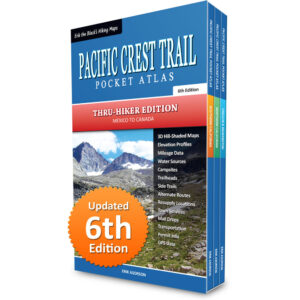
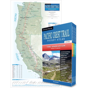
Erik the Black’s Pacific Crest Trail Pocket Atlas: 3-Book Set
Mexico to Canada, 6th Edition
- Ultralight Pocket Guide Books: Each PCT Pocket Atlas measures 4.25 x 7 x 0.2 in. and weighs under 3 ounces
- Pacific Crest Trail Maps: Showing the entire trail, water sources, campsites, trailheads and points of interest
- Mileage and Elevation Data: Including northbound and southbound mileage and detailed elevation profiles
- Resupply Locations and Services: Post offices, maildrops, transportation, food, lodging, outfitters and more
- Downloadable GPS Data: Waypoints and tracks for your smartphone and GPS devices (GPX format)
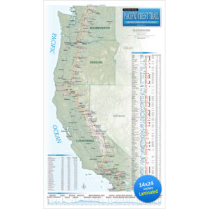
Pacific Crest Trail Map Showing The Entire 2,656 Mile PCT From Mexico to Canada, With Essential Information To Help You Plan Your Hike

Erik the Black’s Pacific Crest Trail Wall Map (Laminated)
15 x 26 inches, 5th Edition
- Pacific Crest Trail Overview Map: Showing the entire 2,656 mile PCT trail route from Mexico to Canada
- Mileage and Elevation Data: For all twenty-nine sections of the Pacific Crest Trail and major trailheads
- Elevation Profile: Showing all the peaks, passes and valleys along the Pacific Crest Trail route
- Roads and Trailheads: Linking the PCT with trail towns and nearby places of interest
- Resupply Locations: Trail towns, post offices, maildrops and hiker services near the Pacific Crest Trail
Complete Guide To Pacific Crest Trail Towns And Resupply Stops, Where You Can Rest, Resupply, Send Maildrops and More

- Resupply Locations: A complete list of 120+ trail towns and resupply stops near the Pacific Crest Trail
- Hiker Services: Post offices, maildrops, lodging, grocery stores, restaurants, laundromats, outfitters and more
- Post Offices: U.S. post offices near the trail where you can send resupply packages via “General Delivery”
- Maildrops: Private maildrops near the trail which accept resupply packages for PCT hikers
- Outfitters: Gear shops near the PCT which sell outdoor equipment, clothing and supplies
- Transportation: Buses, shuttles and ferries near the PCT which service the trail and nearby towns
Ready to Start Planning Your Pacific Crest Trail Hike?
Order your Pacific Crest Trail Maps and Guide Books here
-
Sale!
Erik the Black’s Pacific Crest Trail Pocket Atlas: 3-Book Set
Original price was: $89.95.$49.95Current price is: $49.95. -
Sale!
Erik the Black’s Pacific Crest Trail Wall Map (Laminated)
Original price was: $29.95.$21.95Current price is: $21.95. -
Sale!
Erik the Black’s Pacific Crest Trail Map Bundle
Original price was: $99.95.$64.95Current price is: $64.95.
TRAIL MAPS
POCKET ATLASES
GEAR LISTS
BlackwoodsPress.com
Copyright © 2026 by Erik Asorson